REQUEST A TOUR If you would like to see this home without being there in person, select the "Virtual Tour" option and your advisor will contact you to discuss available opportunities.
In-PersonVirtual Tour
Listed by Tom McArthur. Jr. • McArthur Sanders Real Estate
$ 16,000,000
Est. payment | /mo
359.37 Acres Lot
$ 16,000,000
Est. payment | /mo
359.37 Acres Lot
Key Details
Property Type Single Family Home
Listing Status Active
Purchase Type For Sale
MLS Listing ID 2768464
Annual Tax Amount $4,020
Lot Size 359.370 Acres
Acres 359.37
Lot Dimensions 359 Acres
Property Description
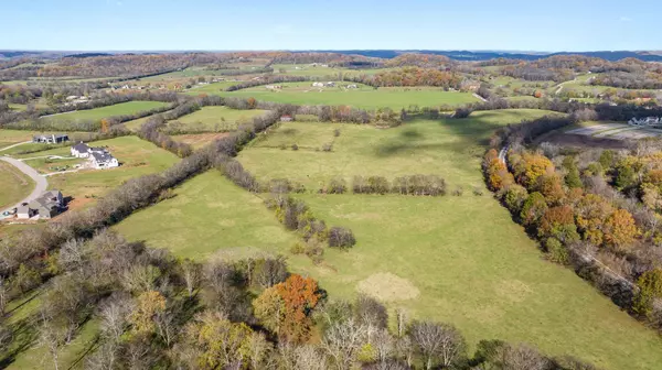
RESIDENTIAL DEVELOPMENT OPPORTUNITY! This Williamson County farm containing +/-359.37 acres has been entrusted to the same family for over 100 years! The ridgeline which extends along the rear (south) portions of the site serves as a backdrop to the rolling fields and multiple water sources which comprise the remainder of the property. The balance of unique physical features, privacy, panoramic views, and the property’s convenient location creates a perfect residential development opportunity or welcomes an individual to carry on a farmstead legacy. Zoned D-1 in the Town of Thompson’s Station. Approximate road frontage: +/-3,286 feet of along Thompsons Station Road West; +/-2,376 feet along Dean Road; and +/-802 feet along Old Thompsons Station Road. The subject’s east and southeast property lines parallel the western boundary of the CSX Railway line some 6,665 feet. The maximum depth of the property from Thompsons Station Road West to the rear boundary is approximately 7,800 feet. Overall topography is rolling over the front (northern) two-thirds of the property with contours ranging from +/-760 feet to +/-850 feet. The rear (south) third of the property reflects some steeper slopes and hills with contours ranging from +/-850 feet to +/-1,000 feet. Approximately 65.0 percent of the site is cleared, in open pasture/crop land with the balance of the site forested (mostly concentrated at the rear or southern portion of the property). Nearby Residential Developments include Whistle Stop (Homes $1.25-$1.65MM); The Hills (Homes $3.0-$4.0MM.); Bridgemore Village (Homes $1.15-$2.0MM); Avenue Downs (Homes $1.4-$1.5MM); Fountain View (Homes $1.15-$1.5MM). 3 miles to I-840 | 5 miles to I-65 | 4 miles to Shopping & Dining in Tollgate Village | 7 miles to Shopping & Dining in Berry Farms | 8 miles to Leipers Fork | 10 miles to downtown Franklin | 12 miles to Williamson Medical Center | 35 miles to downtown Nashville and BNA. Buyer to verify any and all information.
Location
State TN
County Williamson County
Zoning D-1
Interior
Fireplace N
Exterior
Utilities Available Water Available
View Y/N false
Private Pool false
Building
Lot Description Hilly, Level, Rolling Slope, Sloped
Water Private
New Construction false
Schools
Elementary Schools Heritage Elementary
Middle Schools Heritage Middle School
High Schools Independence High School

© 2025 Listings courtesy of RealTrac as distributed by MLS GRID. All Rights Reserved.


